-
2022 autumn Tag birds
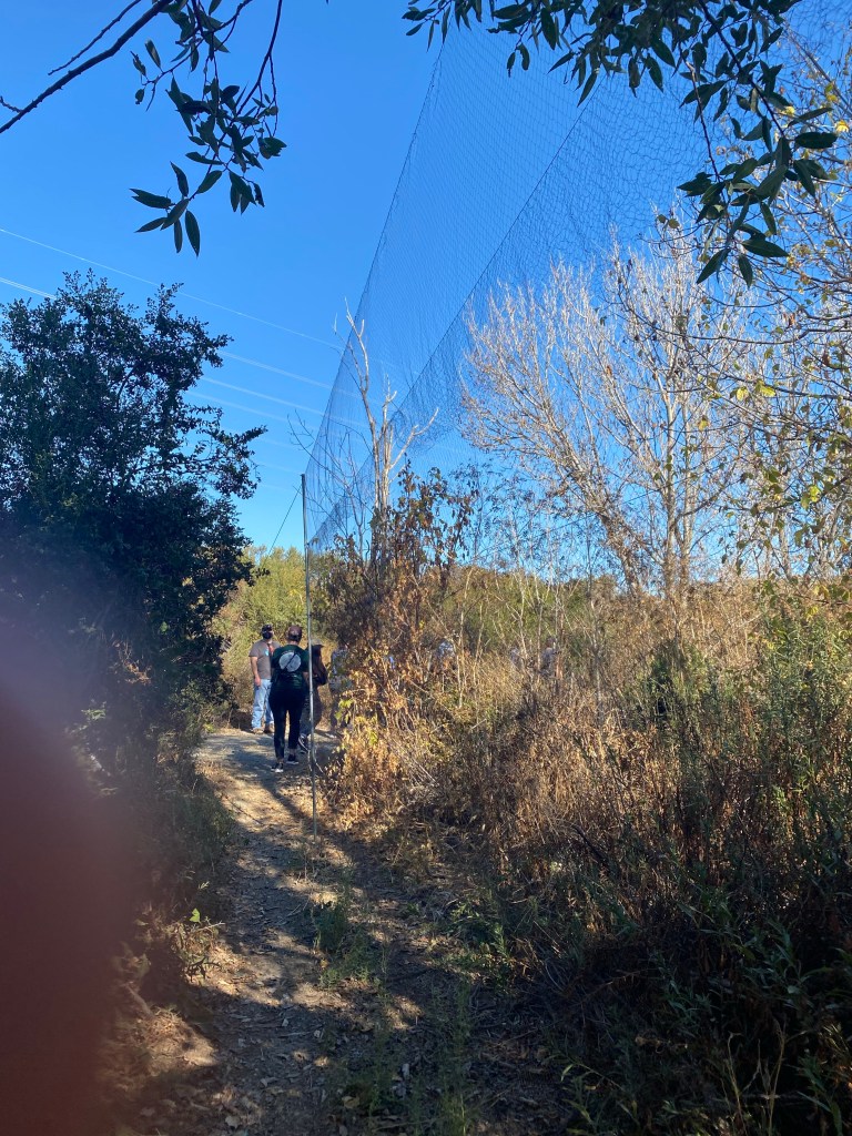
Bird migration season. The bird watching station needs all the help they can get to tag the incoming birds so that they can be tracked. I wanted to try it because it seemed really interesting. I had to go to the bird station early in the morning on the weekends to volunteer for this task.
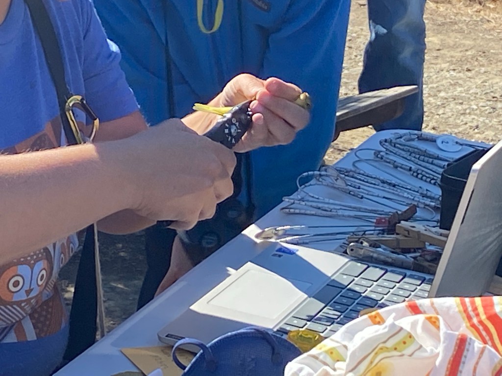
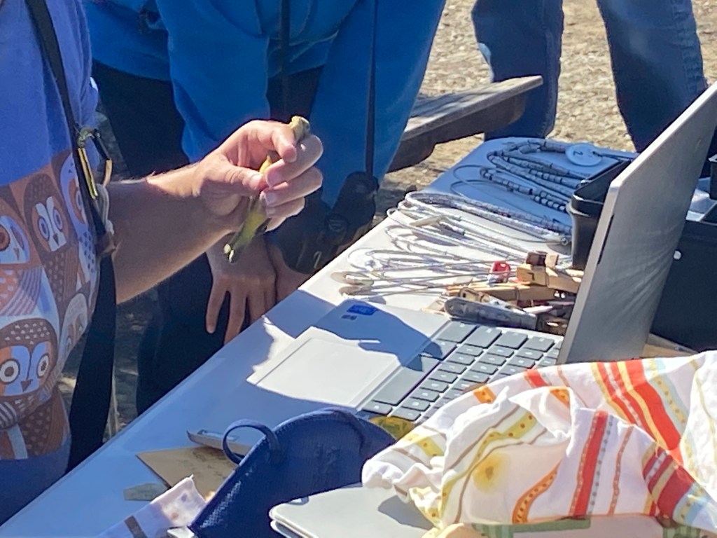
A row of large nets were waiting for the birds, who practically threw themselves into the net. When I got there one day, there were several birds hanging on the net and the staff was plucking the birds from the net. Since the birds are stuck on, it’s not really very easy and it took some effort to get them off. Caution was maintained because the staff was anxious about hurting the birds. The first bird to be liberated from the cage was a yellow warbler. This little bird chirped non-stop, expressing dissatisfaction at having been caught in the net.
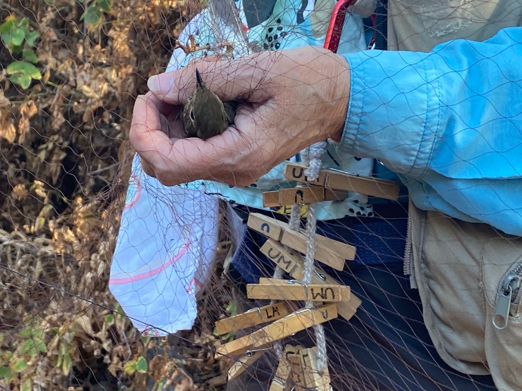

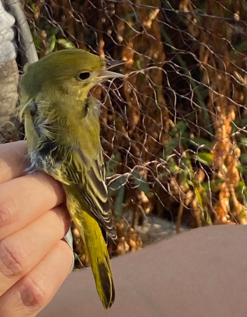
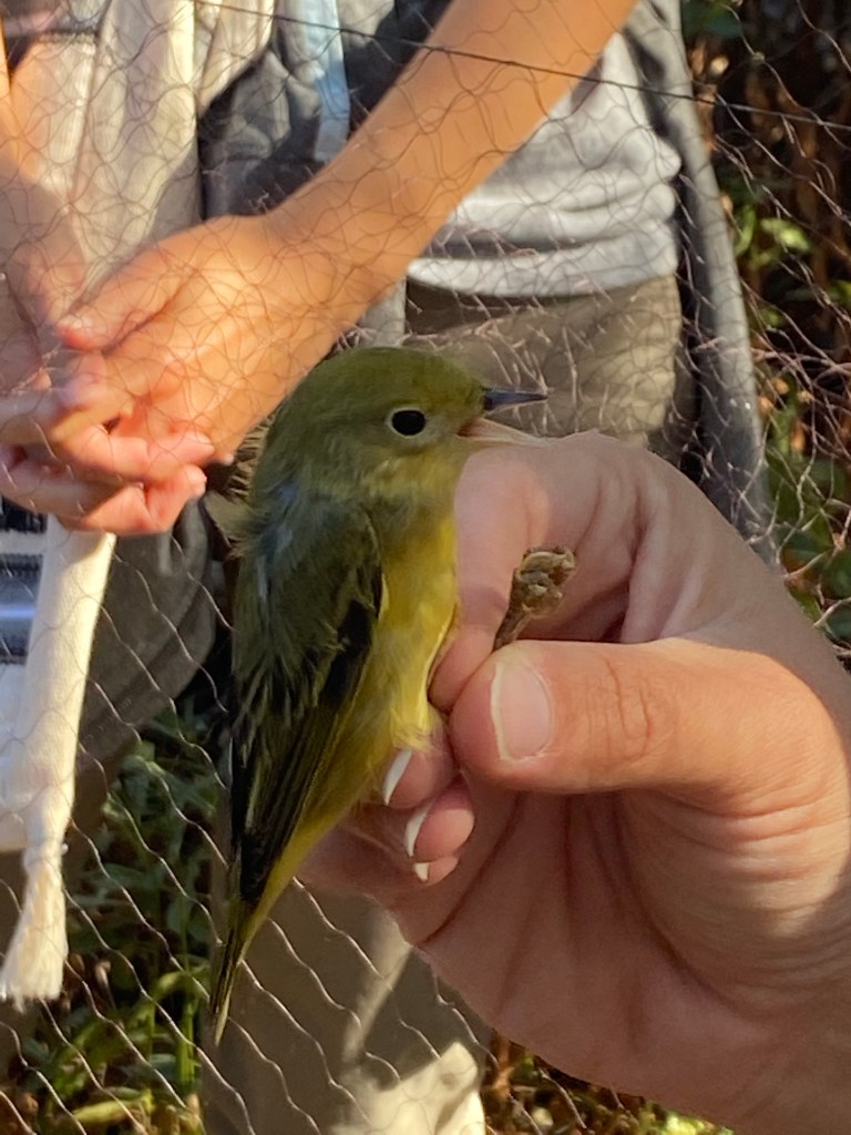
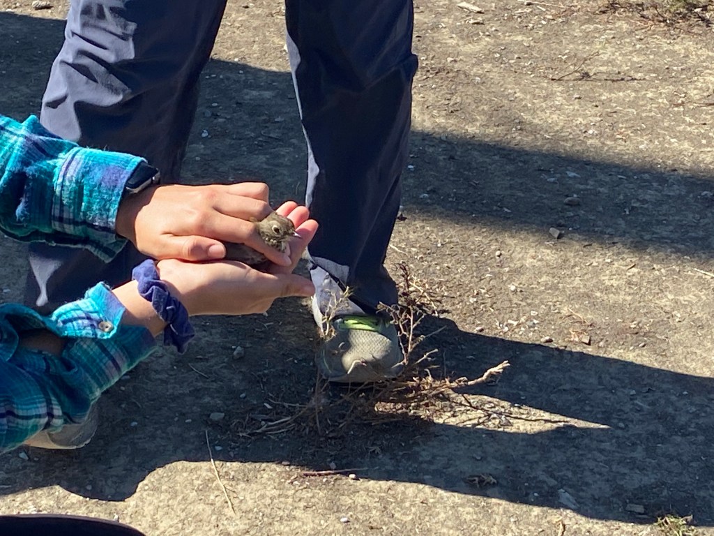
Now that the bird is out of the net, it is ready to have anklets put on. It looked frightened as it lay on the table. Pliers and scissors at hand, the staff carefully started fixing the numbered iron rings to one of the bird’s feet. Since I’m a junior volunteer, I helped with odd jobs like handing the tools to the staff. It is said that when they fly back after winter, their changes can be observed and tracked by the number of their ankles. I always wondered what the probability of getting the same bird in the net was, since there were a vast number of birds that were caught in the net and being tracked. I’m not sure what the probability is, but it is fascinating to see how environmental analysis and tracking is done. When the birds were let go after the operation, they took off into the sky and flew off into the distance. Hopefully next year, I get to see this same bird again and see how it has changed over the course of the entire year.

-
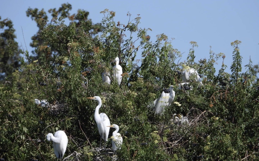
2022 March to July monitoring the egrets during breeding season
In a poem about the egrets, the egret’s combination of pigments, size of its body, and everything about the egret is described in minute detail. The poem goes, “The egret has begun to prepare for hatching, flying in and out to build a nest with grass. When the wind blows, its feathers resemble a wedding dress. It looks like a bride in a wedding dress when it flies in the air.”

Checking up on the egret habitat every two weeks means you’re bound to see something sad and unfortunate. There was tragedy this time I visited, where an egret lay unmoved and my mentor Larry , who is an ecologist from SFBBO said it was dead. I don’t know what the cause of death was as we never found out, but it saddened me. However, it was part of the circle of life.

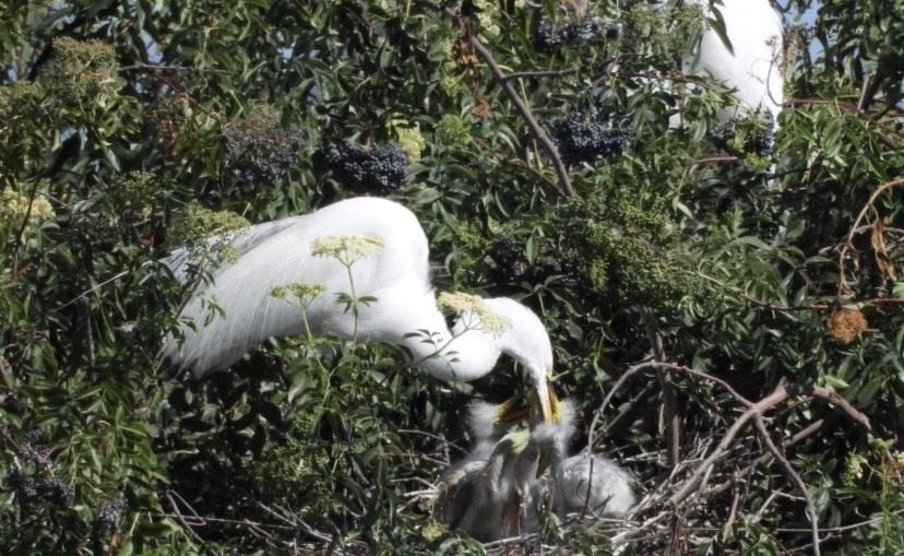
Two months had passed since, and the baby egrets had finally hatched, breaking out of their shells and showing their small heads. It rushed to its mother, who proceeded to feed it. The parents of the babies were busy flying in and out of the nest, providing food for the newborns. The fluffy baby egrets were very cute, and I hope they grow up to be very healthy. Some of the baby egrets were already exploring and curious, wandering out of the nest and practicing flight.

The parents of the egrets were slowly guiding the little egrets, and they seemed to be a happy family. The birds were thriving in their natural environment, partly thanks to the help of SFBBO. Where I live, it is a bustling city and suburb. So I am grateful to have a place in nature to escape to and view the wonderful things that nature has to offer. In another two weeks, the little egrets will fully learn how to fly and the egret flock will leave. The island will return to its pre-breeding silence. I am saddened to know that the egrets will be leaving us for the season to go to other habitats across North America, but I am happy to have the chance to witness the circle of life in front of me.
-
2022 summer Observed least tern during breeding season
The least tern is a rare species due to its limited population numbers. The total population of the least term is estimated to be around 18,000. It’s natural habitat is in Central and South America, and it is a very small bird with an interesting black circle on its head. At the end of April every year, they fly to the sunny shores of California to breed their offspring. Not many of them come to the Bay Area, however. When they do come, you have to be ready and prepared to meet them. The Bay Area Bird Conservation Society sets up habitats and tern hatch areas along the sand on the beaches. Surrounded by iron nets, the iron gates are locked to prevent human access. They also clean up the tern’s homes, clearing surrounding bushes and grass while preventing predators from preying on the terns. Predators include foxes, wild dogs, egrets. Weeding is also done, but it is hard work. To further protect the nests, shells are sprinkled on the nests to camouflage them and protect them from predators.
2 months later, our observation team went to look at the habitats to see if the terns had come. Every intersection has an iron gate with a combination lock ,and it takes up to 8 times to open and lock the gate. The tall gate is fox-proof. After 8 turns, I entered and finally reached the closest observation point allowed by the tern habitat. It was still quite far away, and we had to use professional optical equipment and telescopes to see. I was able to spot a tern that was active in the nest, and eggs that were laid in the habitat. For a novice, it can only be found when the habitat is active. The main goal of observation is to see if there are any natural enemies that can threaten the protected area. On that day, I spotted two egrets in the area which were predators of the tern. The expert I was with told me that if they saw predators, they would be reported to the government, and the government would send personnel from the environmental protection department to remove them. A total of two groups of predators, egrets and hares, were reported.
It surprises me that everyday, we are doing the best we can to save endangered species. Years ago, dams and reservoirs that diverted rivers destroyed the tern’s traditional habitat. It is said that in the 1980s, some bird populations reached as low as only 2,000 individuals. When encountering natural enemies, there is a high probability of not being able to find food. Therefore, the survival rate of terns is very low. I love the environment of the Bay Area, and am trying my best as part of the organization to reverse the negative effects that our way of life has impacted these beautiful animals. Joining a bird protection association is great for me, because it is great to see the progress we’ve made in protecting the beautiful species of bird we have in the Bay Area, and see that the population is steadily increasing with our efforts.
-
2022 Autumn Improving the Habitats of Snow Plovers and Terns
Today, I headed to the dry salt lake where I worked for 3 hours. Terns and snow plovers breed at the salt lake during the middle of May. We clean their habitats before they come and remove objects like garbage and posts. Posts are used by predators, who like to perch on them and wait for these birds to arrive. Removing these posts and vegetation that was encroaching on the nesting habitat ensures that the terns and snow plovers have a safe stay.
Clearing vegetation with the San Francisco Bay Bird Observatory to improve the habitat for endangered species.
The Western Snowy Plover is a threatened shorebird that breeds along the west coast of the U.S. Because of its protected status, the U.S. Fish and Wildlife Service has set goals to restore plover numbers throughout the western Pacific region. In addition to the federal government’s efforts, the South Bay Salt Pond Restoration Project, a 50-year effort to return half of the Bay’s salt ponds back to tidal marsh, has also established goals to increase plovers.
The San Francisco Bay Bird Observatory, the organization I work for, surveys salt ponds to determine the best possible breeding habitats and monitors plovers to determine where they’ll have the most success in breeding and nesting. Each spring, SFBBO biologists band plover chicks to track their movements and survival, and use remote trail cameras to identify predators such as corvids, gulls, and foxes. This way, plovers can be studied for how they behave in the Bay during breeding season and improve their habitats.
Other members of the team working on clearing the vegetation near the San Francisco Bay Area.
The California Least Tern is another endangered species that breeds along the California Coast in sparsely vegetated and flat areas located next to the Pacific Ocean. The San Francisco Bay Area is another popular area for them to breed and nest in. The California Least Tern is another species that the San Francisco Bay Bird Observatory works with and tracks. These terns began showing up to the SFBBO-maintained habitats that were actually meant for Snowy Plover, and the SFBBO has been monitoring Least Terns as well during breeding season ever since.
To attract these birds and improve their habitats, my team and I at SFBBO spread oyster shells at the bottom of the ponds to help camouflage plovers and provide them small habitats during the breeding season. We also cut back the vegetation and weeds to make their habitats neater and easier to settle. Much of this work is necessary to improve the baby chick’s survival rates.
I’m excited to see where our work takes us, and I look forward to seeing how our field work improves the numbers of Least Terns and Snowy Plovers that can call the San Francisco Bay Area home.
-
My First Connection with the Natural Environment: Rowing
Los Gatos Reservoir – My first exposure to a pristine environment
The environment has always been something that interested me. It started with my days on the rowing team, where I’d travel to the Los Gatos Reservoir to attend rowing practice. I started rowing in the summer of 8th grade, and I’d go to rowing practice 6 times a week. This means that I would venture out into the mountains and the reservoir area frequently, putting me into contact with wildlife on a frequent basis. This Reservoir is located in the dense forests in the mountains located between San Jose and Santa Cruz. Much of the forest is untouched, meaning a lot of wildlife lives in these parts. Soaring eagles, herds of roaming deer, vultures circling the sky, varieties of color waterfowl, and birds of all shapes and sizes inhabit the region, and I got to see all of it while I was rowing on the water or doing on-land exercises.
Deer spotted at Los Gatos Reservoir
The diversity of wildlife and the beauty of them, even in this tiny stretch of mountain, captured my fascination with wildlife, and wildlife has become an important part of my life. Observing all the beautiful animals, birds, and deer has made me more conscious about the environment, and preserving the beautiful nature and biodiversity that California has. Ever since my experiences with rowing in nature, I’ve since started other projects to help connect me closer with the environment as well as local conservation efforts.
One of my main projects is my volunteering efforts with the San Francisco Bay Bird Observatory. The San Francisco Bay Bird Observatory is a non-profit dedicated to preserving birds and their habitats in and around the San Francisco Bay Area. This is done through on-field work, like documenting habitat locations, population numbers, nesting locations, and other habitat factors. Joining the San Francisco Bay Bird Observatory is my first step into getting closer to the environment and getting more hands-on with conservation efforts in my local community.
-
2022 summer research with ecologist (part 2)
Tributary of Corte Madera Creek Watershed:
This map was made using a digital elevation model developed from LiDAR (light detection and ranging). Streamstats, a website made by USGS, generates a flow accumulation analysis to determine how water runs off across the landscape. By selecting a lowermost point within the tributary of Corte Madera Creek, Streamstats calculates the land area contributing water to the stream. Streams are shown in blue, and this watershed area is highlighted in yellow. All the rain that falls within the highlighted area flows into the tributary and eventually to Corte Madera Creek.
Some simple statistics based on the basin that Corte Madera Creek resides in. 50-percent AEP flood = when there is a 50 percent chance of a flood occurring every year.
- Ravenswood tidal marsh
- The Ravenswood tidal marsh was the third location that I studied. It was fairly windy, with the area being cool compared to the surrounding area. It was also low tide, with the tide changing twice in one day. There was no shade on the tidal marsh and the only animals on the marsh were some birds scavenging for food. The tidal marsh is on the shore of the bay, with multiple creeks feeding into the Ravenswood tidal marsh. It receives a part of its water from San Francisquito Creek and the other part from the bay. This creates brackish water with part salty and part fresh water, which creates a new environment compared to just salt/fresh water. Near the tidal marsh was a “plot” of pickleweed. They provide cover and some shade for small animals as well as a way to create fresh water from the saltwater that comes from the bay.
- Pearson-Arastradero grassland
- The Pearson-Arastradero was the final location that I studied. The grassland is also around the foothills of the Santa Cruz mountains. During my time at the Pond, the first thing I noticed was the lack of shade and how it had sparse foliage apart from the tall grass. The grassland during the summertime is warm and fairly windy. As a habitat, Pearson-Arastradero grassland is a good place for small critters to hide in. This is due to the tall grass providing cover over a large area. There is also a stable water supply nearby in the form of a Pond.
How is each habitat unique?
Each habitat has unique features that create a unique habitat, which allows different species to live in each habitat. Sausal Pond has dense foliage surrounding it with lots of shade and is a stable water supply, Corte Madera creek is at a low elevation with a cooler and humid climate, the Ravenswood tidal marsh has changing tides which completely change the habitat twice a day, and the Pearson-Arastradero grassland has tall grass that provides cover for small critters to hide in.
How does each habitat change seasonally?
Sausal Pond’s water level would change seasonally, with the water levels becoming lower during the dry seasons and higher during the wet seasons. I believe the plants would still thrive during the dry season as there is still a groundwater supply. I believe that Corte Madera Creek would dry up a bit as its tributaries would also dry up during the dry seasons and would become larger up as its tributaries would become full again while the creek itself gets rainwater directly. Pearson-Arastradero grassland during the dry season would cause dormancy for the grass, while during the wet season the grassland would be lush.
How might each habitat respond to climate changes?
Each habitat could undergo substantial changes, such as if Sausal Pond dries out completely, due to climate change. Here are some hypotheses on what would happen and potential reasons why such an event would happen.
- Higher temperatures, thus causing higher evaporation rates, could lower water levels faster than in the past. Future rainfall is uncertain but may become increasingly variable and occur over a shorter period each year(with the same amount of rainfall), causing the dry season to become longer and drier.
- Plants that are further away from Sausal Pond would most likely dry up due to water scarcity in the coming dry seasons. Animals that were once used to the seasonal pattern of water availability in Sausal Pond would be forced to find new habitats due to sharper wet seasons.
- Corte Madera Creek would eventually dry up as well as its tributaries due to longer dry seasons but would have a fast flow of water during the wet season. This will cause erosion and would affect sediment levels in the water. This would also affect other ponds in the area due to Corte Madera Creek feeding into many others, thus causing lower surface water flow into ponds.
- The Ravenswood tidal marsh would be flooded due to it being close to sea level and the rising sea levels caused by climate change. The pickleweed plot near the tidal marsh would also drown due to its close proximity to the tidal marsh.
- Pearson-Arastradero grassland would also eventually dry up due to longer dry seasons and most of the grass in the area would eventually die over a long period of time.
What measurements can we make to evaluate the health of each habitat and identify long-term changes?
- Water quality:
- Turbidity
- Salinity of water
- pH
- Algae
- Oxygen
- Temperature
- Water quantity:
- Groundwater concentration
- Water levels
- Plant biodiversity
- Section off a plot of plants
- Identifying individual species
- Animal biodiversity
- Identifying individual species
- Soil quality
- Measure the concentration and spatial variability of nutrients
Conclusion:
Through this document, I showed you about how unique these habitats surrounding the Santa Cruz Mountains are, as well as the effects of climate change on these habitats. With this knowledge, I hope to have enlightened you on how delicate these habitats are and how vital they are to the wider ecosystem. I also hope that you become conscious to our own contribution to global warming and strive to make a change for the better of our Earth.
- Ravenswood tidal marsh
-
2022 summer research with ecologist(part 1)
Habitats in the Santa Cruz Mountains Region, California
Introduction:
Natural habitats are vital to animals, plants, and ecosystem functions important to society. These habitats that contain their own individual microcosm are just a minute’s drive away from each other. The San Francisco Bay Area and Santa Cruz Mountains Region contain many unique habitats that support a range of ecosystems. From the foothills of the mountains at Windy Hill Open Space preserve to the marshes of Ravenswood, the habitats exhibit a range of water availability, plant density/variety, and seasonal patterns important to animal behavior. Due to this variability, each habitat is uniquely sensitive to climate changes. It is therefore important to understand how each functions today and how each could change in the future.
Site Description:
The Santa Cruz Mountains run northwest-southeast within the San Francisco Peninsula in central California, USA. The area includes elevations ranging from sea level to 2,500 feet above sea level, with the Pacific Ocean to the west and San Francisco Bay to the east. The terrain in the area is a combination of flat land near the ocean and San Francisco Bay, bumpy land in between the SF Bay and the Santa Cruz Mountains, and there is a steep landscape leading up to the highest elevations of the Santa Cruz Mountains.
The Bay Area has a Mediterranean climate, with the winter seasons being towards the end/beginning of the year and the summer seasons being towards the middle of the year. Being in a Mediterranean climate means that rain follows this seasonal pattern, with rain mostly occurring from around November to April. The rest of the year is in a dry season. Due to the Ocean being in the west, the temperature is usually stable and temperate. However, the temperature still follows a seasonal pattern with higher temperatures in the summer months and colder temperatures in the winter months. I started my studies of the habitats in the Bay Area in July of 2022, the transition between spring and summer. This marks the end of the rainy season and the beginning of the warm, dry season.
The Bay Area is known for its high biodiversity, with many plant and animal species found only in central California. The biodiversity in the Bay Area varies greatly depending on the area depending on elevation, slope, distance from water, and other factors. For example, the foothills of the Santa Cruz Mountains are a mix of open grasslands and dense foliage with creeks and ponds scattered around the area, and the marshlands have a changing habitat with the high and low tides.
Figure 1: Map of the eastern (bay-side) Santa Cruz Mountains surrounding Palo Alto. The black lines show the locations of the Windy Hill, Pearson-Arastradero, and Ravenswood Open Spaces.
Figure 2: Map of the Pearson-Arastradero Grassland in the foothills of Santa Cruz Mountains. Studied Area circled in black.
Figure 3: Tributaries of Corte Madera Creek and Corte Madera Creek are circled in black. They are in the foothills of the Santa Cruz Mountains. Sausal Pond is also circled in the top right of the image.
Figure 4: The Ravenswood Open Space Preserve at the San Francisco Bay shoreline in East Palo Alto. The black circled area shows the habitat I examined.
Science Questions:
What makes a good science question?
- Testable
- Broad enough to be interesting and informative
- Not “yes or no” questions
- Repeatable
- Relevant
This was the “rubric” that I used when trying to make these questions.
What are the habitat characteristics of Sausal Pond, Corte Madera Creek, the Ravenswood tidal marsh, and Pearson-Arastradero grassland?
- Sausal Pond
- One of the first locations that I studied is Sausal Pond. Sausal Pond is in the foothills of the Santa Cruz Mountains within the Windy Hill Open Space Preserve. Sausal Pond is an instream pond because it is fed by and drains into a Sausal Creek. Basic observations of the pond include very dense foliage surrounding the pond, with cattails growing in the water, coast live oaks and other deciduous trees growing around the pond’s perimeter, and some grass and reeds growing along the shore of the pond. Sausal Pond, as a habitat, provides a lot of shade with the foliage that keeps the pond and shoreline cool and can be used as an area of refuge from predators. The pond also serves as a stable water supply for animals to drink from as well as a habitat for small critters and plants to live in.
- What controls the water budget of Sausal Pond?
- Understanding what controls Sausal Pond’s water budget is critical to understanding its sensitivity to climate changes. To do this, I made a crude equation using some of the likely contributors to Sausal Pond’s water budget.
Water Budget Equation:
Gin + S.Fin + R = E.T + SFout + Gout
Gin = groundwater flow in, S.Fin = surface flow in(e.g: streams), R = rain, E.T = evapotranspiration (evaporation + transpiration), S.Fout = surface flow out, Gout = groundwater flow out.
- Corte Madera Creek
- The Corte Madera Creek was the second location that I studied. It is also in the foothills of the Santa Cruz mountains, but at a lower elevation than Sausal Pond. It is a tributary creek that is fed by other tributaries and it eventually flows east into the San Francisquito Creek and eventually into the San Francisco Bay. The creek lies at the bottom of a valley incised by the creek’s water over time. The surrounding area in the creek has a lot of shade, is moist/humid, has a cool temperature, and is home to an abundance of insects. The Corte Madera Creek provides a noticeably different habitat than Sausal Pond, although there is overlap in species because of their proximity.
-
Hello World!


-
Subscribe
Subscribed
Already have a WordPress.com account? Log in now.
